
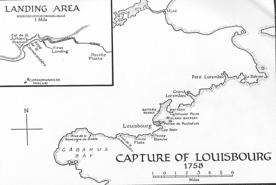
It is time now to once again consider Louisbourg Harbour. An understanding of its configuration will bring a better understanding of the challenge faced by an enemy in getting troops before the walls of Louisbourg. The best description that I have run across, is that given by Richard Brown in his work written in 1869, A History of the Island of Cape Breton.1 One should bring to their ready view the map of Louisbourg Harbour as he or she reads the following:
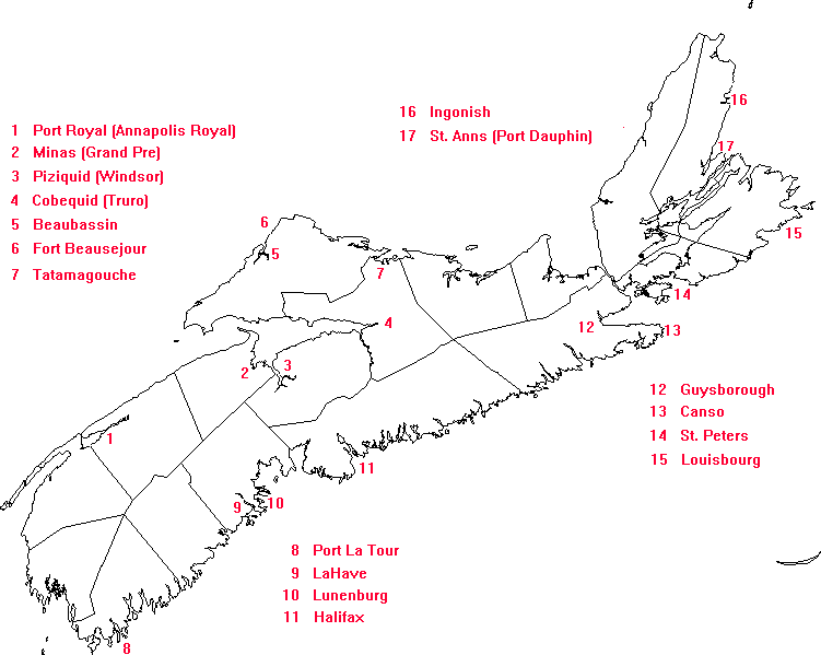
"The harbour of Louisbourg, which is two miles in length and half a mile in width, with a depth of three to six fathoms, communicates with the open ocean by a channel only half a mile in length and one-third of a mile in width, having a depth of six to ten fathoms. A vessel arriving on the coast with a favourable wind, can reach safe anchorage in a few minutes after passing the lighthouse. This great facility of access, without any intervening bay or roadstead, was probably one of the principal reasons why Louisbourg harbour was chosen in preference to St. Anne's. [See #17 on map.] Vessels can ride at anchor with safety in all parts of the harbour, although there is some agitation immediately in front of the town during easterly gales, when the rocky coast outside and the islands at the entrance, not more than half a mile distant, are exposed to the unbroken fury of the waves, and enveloped in immense sheets of surging foam. On the north-west shore, directly facing the entrance of the harbour, stood the Grand or Royal Battery, armed with twenty-eight 42-pounder and two 18-pounder guns. This battery, protected by a moat and bastions on the land side, was said, when garrisoned by 200 men, to be capable of successfully resisting a besieging force of ten times that number. It completely covered the entrance of the harbour, as its guns could rake the decks of any ship attempting to force the passage. On the shore just opposite the Grand Battery, there was a careening wharf, in a snug sheltered cove, for heaving down ships of the largest class, and near the mouths of the small streams, at the head of the north-east arm, a long range of wooden buildings for warehousing provisions and naval stores. From thence to the Barachois [a pond], at the other end of the harbour, the shore was dotted at close intervals by the huts and stages of the fishermen. Rugged hills covered with scrub, terminating in rocky precipices at the water's edge, bordered the eastern shore of the harbour, from the lighthouse to the head of the north-east arm. On the north-western shore, with the exception of small patches of cleared land near the huts of the fishermen and around the Grand Battery, the low range called the Green Hills, extending southerly as far as Gabarus Bay, was still covered by the primeval forest. By referring to the Map of the Harbour and Environs of Louisbourg ... you will observe that the town, situated upon the tongue or promontory lying between the south shore of the harbour and the sea, occupied, including the walls, an irregular quadrilateral area of about 100 acres. The site of the town was elevated some twenty or thirty feet above the sea, but the ground outside the walls was low and marshy, with here and there small ponds and rocky knolls. This broken swampy ground, which extended in one direction to the foot of the Green Hills, and in the other nearly as far as White Point, presented great obstacles to the advance of a besieging army."What was necessary was to get within hammering range of Louisbourg; the conditio sine qua non, however, was to gain access to Louisbourg Harbour, or, at least to have control of its shores. Because of the strategically placed French armament, no wooden sailing ship could pass without permission, else, it would almost certainly and immediately be turned into a mass of floating splinters. The invading troops would have to come in overland from the hard and wind swept coasts of the Atlantic Ocean such as is to be found to the northeast and southwest of Louisbourg. Such a feat was bound to test the wits of even the most determined military men. When striking their plans at Halifax,2 the English officers had determined that the troops were to be landed at three points with most of them coming ashore to the west of Louisbourg at Gabarus Bay. Wolfe was to land on the shores of Mira Bay. Monckton was to land at Lorembeck on the shores to the north of Louisbourg.3 Once landed, these forces, it was intended, would march on Louisbourg. These landings and the marches would take the attention off the principle landing place, Gabarus Bay. As it turned out, Amherst, arriving only after the invasion fleet had left Halifax Harbour, nixed these plans -- presumably, because he was against exhausting his army by hard marches through, what in part, would be a tangled wilderness. Amherst's plan was to be a front-on attack and land his army at a point somewhere along Gabarus Bay; and, thus, to be but a few miles from their target.4
At Gabarus Bay, as both sides knew equally well, there were but three potential landing places: Fresh Water Cove (Anse de la Coromandiere), Flat Point (Pointe Platte) and White Point (Pointe Blanche). (See map.) The French had no choice but to spread their limited forces and defend all three places. So, too, there was the potential landing place in a cove to the east of Louisbourg, Grand Lorembec, which these days we know as Lorraine, about three to four miles up the coast. The French did not consider it to be a likely landing place as the terrain, between it and Louisbourg, for the most part, was rough and wooded; further a march would have to be made around the exposed perimeter of Louisbourg Harbour.
"Therefore, only 450 of the 2,800 French regulars deployed outside the fortress were east of the harbour entrance. The shore to the west of the town, however, presented several likely landing places. Colonel de St. Julhien of the Regiment d'Artois had 1,000 men entrenched at Anse de la Coromandiere (referred to as Fresh Water Cove by the Royal Navy), with one 24-pounder, four 6-pounders and six swivels. Further east at Point Platte [Flat Point] were 930 men with four 6-pounders, six swivels, and a mortar. Still closer to Louisbourg, some 350 men with one 24-pounder and six 6 pounders were at Pointe Blanche. Only 75 men were posted at Cap Noir, but they had two 24-pounders. In addition there were militia, Acadians, and Indians. Although a landing was not considered likely to the west of these beaches, small flank parties had been despatched to watch the Anse de la Montaigne du Diable and the bottom of Gabarus Bay."5
As for the overall strength at Louisbourg: the French had, in addition to the civilian population6 at Louisbourg, 5637 military men. This number consisted of army men of the garrison (3031) and the rest (2606) were naval forces which had managed to get into Louisbourg Harbour.7 Hitsman and Bond, who deal with the matter in an authoritative manner, set the following numbers out in one of their articles:
"A battalion of Swiss mercenaries (Volontaires Etrangers) arrived from France during the early spring of 1758 and a regular battalion of the Regiment of Cambis reached Louisbourg just ahead of the invaders. The total regular strength, including non-effectives, was brought to approximately 3500 men by 24 companies of Troupes de la Marine, raised in North America, and two companies of artillery. There also were some Indians and Acadians, the militia formed from the local inhabitants and the crews of the 10 ships remaining in the harbour."8
The Cambis Regiment, to which Hitsman and Bond make reference, is a French regiment that particularly attracts our attention. Anticipating an attack, the Cambis Regiment9 was sent directly over to Louisbourg from France in 1758.10 They had been transported under the escort of a French squadron headed up by Chaffault de Besne. They were off Louisbourg by the end of May, however, Besne, in order to avoid Hardy's much larger fleet, which by this time was patrolling along the coast, sailed north over the tip of Cape Breton to Port Dauphin (Ste Ann's; see #17 on map). The Cambis soldiers were taken, in two lots, by smaller vessels along the coast, east, to Baie des Espagnols (Spanish Bay, the shores on which one will find today the city of Sydney). These soldiers were then marched overland to Louisbourg; likely they followed the same 20 mile route which today is marked by highway No. 22, running from Sydney to Louisbourg. The first lot11 of the Cambis Regiment were to arrive at Louisbourg on June 7th; and, not a day too soon, as the British transports laden with troops were, by then, at anchor off Gabarus Bay and making ready to launch their landing craft. We can but only imagine the proud soldiers of the Cambis Regiment marching through the gates of Louisbourg to the cheers of their fellow countrymen, who had to be much encouraged by this military reinforcement. Proud, maybe, these men of the Cambis Regiment; but they had to be showing the sure signs of a long sea voyage and a recent march through the bush.
The exhausted men of the Cambis Regiment, while cheered with food and drink, were sent almost immediately out the gates through which they came. There was no time for a respite. Governor Drucour immediately assigned these new arrivals to the shore positions at White Point and Flat Point. (See map.) Soon, they were all dug-in along the shore and looking out into Gabarus Bay where there was, in conspicuous view, a huge British fleet of war ships and transports, all riding in the wind on their rodes with their hooks down.
[NEXT: Pt. 7, Ch. 8 - "The Landing."]